250 years after the Expedition, you can follow in its footsteps and see the same sites and landscapes they would have seen via the Juan Bautista de Anza National Historic Trail. You can experience this connection between our region’s ancient past, early modern past, and present by foot, bike, or by car.
About the Expedition
Who Was Juan Bautista de Anza?
Juan Bautista de Anza was a Spanish military captain, born in Fronteras, Sonora (about 30 miles south of present-day Douglas, Arizona). He was of Basque heritage and was considered a criollo – someone of full Spanish descent born outside of Spain itself. Prior to the 1775-76 Expedition, he had led several other exploratory and migratory expeditions between Sonora and California.
Who Went on the Expedition?
The expedition consisted of about 240 people, 1,000 head of cattle, and many horses and mules. The group consisted of individuals from a variety of backgrounds, all seeking greater opportunities and a better life.
There were 42 men, 39 women, and 119 children on the journey. They were joined by soldiers, vaqueros (cowboys) and muleteers to manage the livestock, blacksmiths, laborers, cooks, and three priests. One of these priests, Father Pedro Font, kept a detailed diary, which is used by historians to determine the day-to-day route of the expeditions, and the location of campsites.
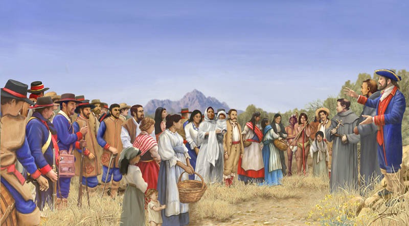
The Anza Expedition at the Oit Par campsite. Anza is depicted on the right of the photo, wearing blue, red, and white. Illustration by Bill Singleton.
Why Did the Expedition Happen?
The 1775-76 Expedition, like others Anza had led, was not a journey of conquest, but rather, it was one of migration. The Spanish government was seeking to move civilians into the area around the San Francisco Bay, to strengthen their claim to it and northern California. In the same time period, the Russian Empire had begun setting up forts along the Pacific Coast of North America.
The Spanish Empire was unique in that they moved women, children, religious leaders, livestock, and other civilians into their colonies to create actual towns and cities, unlike empires such as Russia who only set up forts, inhabited by military-aged men.
The Expedition's Route
The expedition’s final gathering place before setting off was the Presidio of Tubac, although many of the members had already traveled from Sonora and Sinaloa.
In Southern Arizona, they followed the Santa Cruz River, and then the Gila River west to present-day Yuma. They utilized these lifelines in the desert, just as Native Americans had for centuries before, and that we in modern Marana use centuries later.
The expedition passed by many famous historic sites in Southern Arizona, such as the San Xavier del Bac Mission, the Tubac Presidio, and the Presidio of Tucson, all of which were standing and active at the time of the expedition. These sites are all part of the Juan Bautista de Anza National Historic Trail today.
The Expedition stopped to rest at the San Xavier del Bac Mission, which was already active and thriving in 1775.
The Expedition’s route took it approximately 11 miles through what is now Marana, on October 27th and 28th, 1775. They camped overnight at two sites in Marana and rested during the day at another. The campsites were known as Puerto del Azotado and Oit Par - and you can visit them today!
2025 marks the 250th Anniversary of the Juan Bautista de Anza Expedition’s journey! Create your own adventure along the trail in Marana and Southern Arizona to celebrate.
Puerto del Azotado
The Puerto del Azotado campsite is located at the present-day El Rio Preserve (10190 N. Coachline Blvd., in the Continental Ranch neighborhood). The area maintains a riparian wetland environment, much like what the area around the Santa Cruz River would have looked like at the time of the Expedition. You can see over 260 species of birds and other wildlife at the preserve. The campsite’s location is clearly marked with an Anza Trail sign and other interpretive panels.
The El Rio Preserve provides excellent access to The Loop Shared Use Path, where you can bike or walk a section of the National Historic Trail.
For a look even further into the past, visit Los Morteros Conservation Area, a well-preserved example of a Hohokam village site located just to the south.
Oit Par
The second campsite, Oit Par (thought to mean “Old Town” in the O’odham language; and sometimes spelled "Oitpar" or "Oitpars") is located just beyond the Marana Town Limits, right where Trico Road crosses the Santa Cruz River. The site is marked with interpretive signage and a shaded area.
The Oit Par site is also located near the Marana Pumpkin Patch, one of Southern Arizona’s premier fall attractions.
If you look to the west from Oit Par, you can see several small mountains and hills. These are located in Ironwood Forest National Monument and would have been viewed by the Expedition’s members.
CreditThe Oit Par campsite features a picnic shelter, interpretive signage, and parking, with views of the Catalina Mountains in the background.
Marana Heritage River Park
Around mid-day on October 27th, 1775, the expedition rested near what is now Marana Heritage River Park. An interpretive sign along The Loop marks the approximate location where the expedition rested.
PicturedThe interpretive sign indicating where the Expedition rested near Marana Heritage River Park.
The Trail Today: Walk, Bike, or Drive It!
Like many National Historic Trails, the Anza Trail does not follow the exact route of the expedition for most of its course. Instead, it follows the general route of the expedition, and is meant for visitors to be able to experience the heritage and cultural contributions made by it.
Walk or Bike the Trail
Throughout Southern Arizona, there are many places that you can walk or bike sections of the trail, that closely follow the route the expedition would have taken. In Marana, you can follow it via The Loop Shared Use Path, between the El Rio Preserve and just beyond Marana Heritage River Park. This is the route the expedition would have followed the first half of their day in Marana. It's also the same route used by some of the country's top cyclists every February in a time trial prologue to the Tucson Bicycle Classic.
You can access The Loop at the Puerto del Azotado Trailhead in the southwest corner of the preserve, just off of Coachline Blvd. The trailhead is clearly marked with a Juan Bautista National Historic Trail sign.
PicturedThe Loop follows the route of the Anza Trail through much of Marana and Tucson. This photo is near the Puerto del Azotado Trailhead at the El Rio Preserve.
Drive the Trail
The Juan Bautista de Anza National Historic Trail also features a designated Auto Route, which connects several of the historic sites, including the ones in Marana and Southern Arizona, following the route of the expedition up to San Francisco. It can be a great way to experience the history and heritage of the trail, especially during the hot summer months.
Anza Trail Auto Route markers look like this in the Town of Marana......and like this in unincorporated Pima County.
Coming from Tucson, head north up Silverbell Road, which parallels Interstate 10 and the Santa Cruz River, towards Marana. Follow Silverbell Rd. through the Continental Ranch neighborhood, until you reach Twin Peaks Road. Continue straight to Coachline Blvd., and turn right. The El Rio Preserve, and the Puerto del Azotado campsite, will be located on your left.
The route continues along Silverbell Road across a low mountain pass. This pass is the actual “Puerto del Azotado”, and the small extension of the Tucson Mountains it passes through was known by Native Americans as “La Frente Negra”, according to Fr. Font’s diary.
The low area in the center of this photo is the actual "Puerto del Azotado" mountain pass. The mountain on the right is called "La Frente Negra" in Fr. Font's Diary.
After the pass, Silverbell Rd. becomes Lambert Lane, and then turns and becomes Airline Road. Follow Airline Road to Avra Valley Road, and head west on Avra Valley Rd. You’ll pass by Marana Regional Airport, and if you’re hungry, you can stop by Sky Rider Cafe for a delicious, diner-style experience with an aviation theme.
Turn left once you get to Sanders Road, and then take the first left onto Silverbell Road. Continue until you reach Trico Road, and head north. The Oit Par campsite is located right before you cross the Santa Cruz River; the parking area is on the right.
Look for this sign on the east side of Trico Road, immediately south of the Santa Cruz River, to find the Oit Par campsite.
If you continue heading west on Silverbell Road or Avra Valley Road, it’ll take you into Ironwood Forest National Monument. You can also continue north on Trico Road to Pinal Air Park Road, which will take you back to Interstate 10.
Make Marana Your Base Camp
Marana is not only a great home base for exploring the sites along the Anza Trail in the Town itself, but all of the other important sites passed by the Expedition in Southern Arizona.
The San Xavier del Bac Mission, the Presidio of Tucson (located in Downtown Tucson), the Tubac Presidio, and Tumacacori National Historic Park are all located within an hour’s drive of Marana via Interstates 10 and 19.
Discover one of Marana’s hidden gems for birding, walking, and connecting with nature. El Rio Preserve is a 104-acre riparian habitat along the Santa Cruz River that attracts more than 260 species…
Take a step back in time at this well-preserved Hohokam village site. Named after the mortar holes found in volcanic rocks throughout the site, Los Morteros is a well-preserved Hohokam village site…
The Chuck Huckelberry Loop, an extensive network of paved pathways and bike lanes, offers an incredible 137 miles of scenic routes encircling the perimeter of Pima County. This shared-use system connects people…
Mission San Xavier del Bac is a National Historic Landmark, founded as a Catholic mission in 1692 by Father Eusebio Kino, who played a significant role in the history of Southern Arizona…